Tuesday, May 31, 2016

Day 18 Tuesday, May 31 Redding to Crescent City, California

We were up by 6:15 AM and went to breakfast with Betsy and Brett at Black Bear Diner.  After breakfast, we drove CA Highway 299 west out of Redding toward the Trinity Mountains.  We had two road construction delays enroute to Big Flat, CA.  Our first stop was for coffee at the Strawhouse. Julia Ellis, the proprietor, was very welcoming and introduced us to Russell, her nephew.  We enjoyed our coffee, tea, and scone on the back patio next to the Trinity River. 


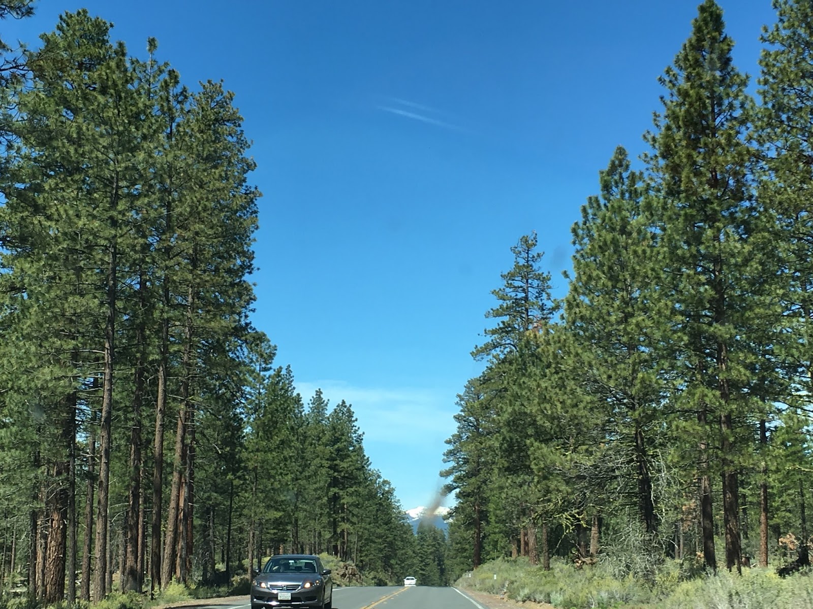
I was thinking as we climbed continuous winding curves upward…if our car could talk, she would probably say “I just delivered you all the way across the farms of the midwest, the great plains, the Rocky Mountains of Colorado, the Canyonlands of Utah, the desert of Nevada and the mountains of the California Sierras, and now you want me to climb and brake through the Trinity Mountains of Western California?!?”  No, I would answer, I am going to ask for one more favor before we are all done… but I will ask for that later…

After winding our way down out of the mountains,  we arrived at CA. Highway 101…as far west as we could go without getting the front bumper wet in the Pacific Ocean! 


We turned south and had lunch at a cafe on the square in Arcata.  Afterward, we explored Humbolt State University nestled on the hillside in pine and redwood trees.  We visited the track/stadium and it must be one of the few stadiums to be encircled with the mighty redwoods giants…no wonder they call it the “Redwood Bowl”.


We drove north on 101 and spotted Elk in an open field.  We saw more just off the road and still more in Prairie Creek Redwoods State Park.   We saw them a fourth time just south of Crescent City. 


I went back to Paula, the Impala, and said, “Remember that last favor…now we are going to ask you to go 16 miles on a  dirt and pot-holed road up and down hills through a forest on narrow roads to deliver us to Fern Canyon.”  Paula moaned but drove on… We arrived at Fern Canyon within Prairie Creek State Park.  This natural ravine, not far from the ocean, has a creek running through it.  The Park Service put planks down so visitors could traverse the shallow creek and explore the green canyon.  The distinguishing feature is the fern and moss cascading down the walls.   We agreed that Fern Canyon was the highlight of the drive.  It had the feel of a prehistoric environment and was a natural choice as the setting for the movie “Jurassic Park II”.


At 5:50 PM we rolled into Crescent City, our final destination.  We ate at a local restaurant for dinner and took a short drive behind our hotel.  As we passed the beach, we saw sea lions on the jetty. In the background, we could see the lighthouse, on the rock against darkening skies.  We finally settled into our hotel.  We phoned Dottie, our contact, at the Lighthouse to let her know we arrived, and made arrangements to move in tomorrow.

Thus ends Phase 1 of our journey; the drive across America to assume our duties as lighthouse keepers.  After 3,907.4 miles, including a half dozen National Parks and at least as many State Parks, we are happy to be here and eager to become the best lighthouse keepers we can be.  Join us tomorrow as we begin our duties!


Monday, May 30, 2016

Day 17 Monday Memorial Day Reno, Nevada to Redding, California

We packed up and departed under crystal clear blue skies.  The casinos of Reno were wasted on us as we saw them disappear in the rear view mirror as we headed north to Sparks and points west beyond.   Within an hour we entered California.  Again, we were guided by mountains throughout.


We made a stop in Susanville.  We made a few more stops for photos as we approached Lassen National Park.  The centerpiece of the park is Mount Lassen itself, 10,463 feet.  This is a volcanic mountain which last erupted in 1917.  We entered a huge area of ponderosa pines before and during the Lassen area on California Highway.


As we approached Redding, we touched base with our son-in-law, Brett, and made arrangements to meet at Cicada Cantina.  This was our next stop.  We finished the Albon book just as we reached the outskirts of Redding.  We highly recommend this book, especially if you love music.

After a nice visit with Brett over lunch, we returned to the apartment and unloaded.  We shared our adventures with Brett then jumped in the car and visited Shasta Lake and Dam.  As Shasta Dam controls the flow of the Sacramento River, it is a very important asset for California. We walked on top of the massive concrete structure and took in the scenery, including Mount Shasta which is the fifth largest mountain in California at 14,179 feet.  It is visable from Redding, as is Mount Lassen.


Upon our return,  I slipped out for a jog in the 90+ heat on the Sulphur Springs trail which originates at the Sundial Bridge over the Sacramento River.  Brett made a delicious dinner and afterward, we went to work on the blog.  Betsy is returning home from friend Liz’s bachelorette outing back in Ohio. We will get to see her briefly before we head out and Brett and Betsy both return to work…

Welcome to California - our home for the next month.  Thanks for checking in on us!  Join us tomorrow as we complete Phase 1 of our journey.


Day 16 Sunday, May 29 Ely to Reno, Nevada

After breakfast we rejoined Nevada State Route 50 west - also known as "The Loneliest Highway in America".  We toured past miles of sagebrush and constant mountains that served as travel companions since we left Ely.  We were prepared for pure sand, but what we found in the Nevada desert was more plant life than expected.  The route also involved more elevation changes than I imagined.  There were four summits rising from the high plateau.  The highest of which was the Austin Summit at 7490 feet.  I had no idea the interior of Nevada was at this elevation.  The positive effect of this was that the temperature was very moderate and comfortable despite the sunny blue skies.  Teare spotted an owl on the road, we also spotted antelope, horses on the open range, and numerous magpies.  At one point we pulled over next to a sea of what appeared to be lavender.  We stopped in Austin at a throwback cafe and bought a cold drink for the road.


Beyond Cold Springs, Teare spotted white sand up ahead and we were both surprised to see a mountain of sand north of the highway.  We pulled in to discover Sand Mountain & Recreation area.  There was a huge parking lot full of RV's, trucks and cars.  There were several trailers with ATV's in various stages of unloading and the pure white mountain had several ATV's racing up and down its slopes.  We also noticed a huge lizard on a building at the recreation area.  As we were leaving, we passed by an original Pony Express stop as we continued our journey west.


The map indicated that the Fallon Naval Target Range of the US Air Force was immediately to our south...we did not stop there...  We did pull in to see what we could see at the Fallon Naval Air Station, better known as the location of the Top Gun school for fighter pilots.  Of course it was sealed up tight but we had to give it a look just in case we might spot a fighter jet.  We stopped in Fallon for lunch and took a break from the lonely highway.  We noted that even the little towns like Ely and Fallon had casinos.  In both cases, MULTIPLE casinos...


Our final leg was from Fallon to Reno.  We listened to The Magic Strings of Frankie Presto by Mitch Albon the entire trip across Nevada.  We were so engrossed in the story, we missed our exit for our hotel in Reno!  Reno is a bustling city, even on a Sunday afternoon.  We finally located our hotel and were happy to take a break from the road.  Our entire trip took eight hours with more than a few stops for photos, food and attractions.

We went to dinner in Reno and came back to call it a day.  We survived the Lonely Highway and have one state to go!  Don't worry, I still have a few Twizzlers left...        

Sunday, May 29, 2016

Day 15 Saturday, May 28 Hurricane, Utah to Great Basin National Park / Ely, Nevada

Hey - when I said you could have some twizzlers, I didn’t mean the whole bag!

The first segment of our day involved driving about 3.5 hours to get up to the Great Basin National Park in Nevada.  We climbed a couple summits and mostly wide open land which were designated as open range territory.  This meant watch out for cows because they might decide to cross the two lane road as you are doing 65 miles per hour - and there is no fence to stop them.  We also saw similar signs for horses - which led us to wonder if there might be some wild horses on the range.  We did spot pronghorn antelope and almost hit some voles scurrying across the highway.


The range has a beauty of its own.  While lacking trees, the semi arid landscape has a variety of sage brush and wild flowers.  Also, we were always within sight of mountains though they may be some distance away. The road was so straight that with cruise control there wasn’t much to driving the car!  We enjoyed being in the wide open spaces of the great American West.


We began our visit to Great Basin at the Visitors Center.  We learned that the Great Basin Region encompases all of Nevada, and portions of Utah, California, and Arizona.  We began our exploration by driving the Wheeler Mountain Scenic Drive.  This was a steady climb to a trailhead over 10,000 feet in elevation.  We saw some incredible vistas during this drive.  It was snowing in the parking lot at the end of the drive.  At 13,063 feet, Wheeler Peek is the highest point in the park.  We stopped at the Mather Overlook.  We did spot a golden eagle that seemed to just hang in air as the thermals provided the lift he needed to stay aloft. 


After our drive up the mountain, we drove three miles down a dirt road to the Baker Creek Trail.  This 3 plus mile hike was a strenuous climb given the trail head was already at 8000 feet.  We esimated our distance at 1.5 miles in 52 minutes on the way up.  This came with plenty of stops to drink water and breathe…  We passed a rock field, crossed Baker Creek a couple times,  and saw more beautiful mountain wild flowers.


Our final stop in Great Basin was a ranger-led tour through the Lehman Caves.  The caves were lit enough so that it was safe to walk, however, you did have to be careful to watch your head on stalagtites which came down from the ceiling while trying to watch where you were stepping.  There were times when you had to turn sideways or duck down to get through the openings.  We learned how caves are formed and how the various formations are naturally created.  This was a unique way to cap off our visit to Great Basin National Park.


We drove the 52 miles to Ely and the first thing we did was find a place to eat.  Low and behold we run into Chris, a young man we met at the Mather Overlook at Great Basin…  We spent several minutes visiting, then found our hotel and called it a day.   Welcome to Nevada!


Friday, May 27, 2016

Day 14 Friday May 27 Zion National Park / Hurricane, Utah (Two weeks on the road)

Having scouted Zion the previous day, we had a clear game plan.  We would drive to the Visitor Center, board the park shuttle, take it to the far end of Zion Canyon and hike to the Narrows.  The Narrows is where the canyon narrows down to a point where if you want to keep hiking, you need to get into the icy Virgin River.  We hiked the Riverside Trail up to the narrows and opted to stay dry.  It was a gorgeous hike along the river between the canyon walls.  The canyon walls rise to 7000 feet which is 3000 feet above the canyon floor which is at 4000 feet.  This 2 mile trail was very popular and very easy. 


We returned via the sandy trails along the river wherever possible.  We were very glad we did the Riverside trail.  

We took the shuttle to the Grotto stop and refilled our water bottles for our hike up the Kayenta trail.  This trail involved a climb part way up the canyon wall and was totally different than the Riverside trail.  This climb provided views down river that you could not get from the bottom of the canyon.


We observed beautiful wild flowers and various critters including begging squirrels, chipmunks, a variety of birds and even a snake that crossed in front of us on the trail.


The Lower Emerald trail descended back to the river and the footbridge delivered us to the Zion Lodge.  We went into the Lodge for lunch and ended up at an outdoor table on a second story patio.  We decided to resume hiking and picked up the Grotto trail which took us to back to the Grotto in the park, effectively completing a 3 mile loop.  

From here, we took the shuttle to our last hike of the day.  This was short but steep up a steady incline to another overhang entitled Weeping Rock.  The views from here were worth the half mile climb.  The ferns and flowers were growing from the sheer rock face on the humid shady hillside.


We felt good physically after our hikes as we boarded the shuttle for the 40 minute ride back to the Visitors Center.   A half hour later we were back at our hotel in Hurricane.  Teare caught up on emails while I went for a 3 mile jog in the high plateau desert town.  

We walked a couple blocks to dinner while watching the Cavs win the Eastern Conference Finals and punching their ticket to the NBA Finals.  We returned to our hotel to enjoy the post game.  What a perfect ending to a perfect day!   

Tomorrow holds the promise of new locations and adventures.  Our trusty Impala is raring to go, so hop in the back seat, have a couple cherry twizzlers and come along with us…


Thursday, May 26, 2016

Day 13 Thursday, May 26 Bryce National Park / Bryce Canyon City to Zion National Park / Hurricane, Utah

We decided to watch the sunrise at a place aptly named Sunrise Point in Bryce Canyon National Park.  To pull this off, we arose by 5:10 AM and headed to a cold and breezy Bryce Canyon.  We were there in plenty of time as the clouds in the eastern sky prolonged the event.  When the sun finally rose above the clouds, we noticed that everyone on the overlook had their back to us.  It was then we realized the radiant red glow eminating from the rock formations BEHIND us!  When you experience a sun rise at Bryce, you not only get the conventional rising of the sun but you are treated to the mountains awakening to their natural red colors.


We had a deer encounter in the parking lot at Sunrise Point.  The deer wanted to join her family and I was in the way!


Our next adventure involved a 320 foot, 1 mile, moderate descent into the canyon via the Queens Garden Trail from the 8000 foot elevation of Sunrise Point.  The rock formations here resembled giant figures or chess pieces.  We did numerous switchbacks on the hard packed dry dirt trail.  At the bottom, we were able to look up at the centerpiece of the rocks to a likeness of a queen in full regalia.  Thus the name of the trail.  Since it was still only a little after 7:00 AM when we began our hike, we had the descent trail to ourselves which was a luxury in a park as popular as Bryce Canyon.  Again, we shot several photos as the scenery constantly impelled us to try to capture the view.


After our hike, we visited the lodge and had breakfast.  The lodge was historic and modestly quaint.  We drove out to Rainbow Point at the far end of the park.  There was more white in the rock at the southern end.  We retraced our route with the addition of a couple overlooks.  We experienced thunder snow as we pulled into the Ponderosa Canyon overlook.  Afterwards, we continued to the Paria View overlook.  All of these provided a different view of the mountains and foliage.  In consideration of the weather and the fact that we had seen most of the park, we left Bryce Canyon and headed west on Utah Route 12.  Again, we had that feeling that our hike had been an incredible experience and each new exploration seemed to rival or at least offer something new from those that preceded it…

We arrived in Zion National Park in a little over an hour.  We entered the park by driving Route 9, which crosses the park from east to southwest.  There are vast sections of the park that are only accessible by ATV or foot.  We found Zion to be different once again.  The improved public areas of Zion are dominated by two main canyons - each spectacular in their own right.  The initial canyon involved a lot of vertical change and switchbacks, lots of people and limited space to pull off the road.  Still, the views were impressive and it was hard to keep eyes on the road while driving.


The other canyon, (Zion Canyon) is only accessible by park shuttle - which we also did.   This drive along the floor of  Zion Canyon runs at the very bottom along the Virgin River.  It was more relaxed as it wound through more trees and grasslands.  Leaving the driving to the bus driver did not hurt either… The rain continued to fall and this influenced our decision to ride the shuttle as opposed to hiking.  Photo taking was limited due to the weather.  We spotted rock climbers half way up a sheer rock face that dwarfed Wall Street from Moab.  Our bus driver was also a lot of fun.  She reminded us of Melissa McCarthy.


Route 9 took us all the way to Hurricane.  This would be our address while in the Zion area.  We checked in, explored the town, had dinner, and returned to our room.  Since we allotted more time for Zion, we will provide more detail on our exploration of this beautiful park in our post tomorrow.  Until then, take care all!


Wednesday, May 25, 2016

Day 12 Wednesday, May 25 Capitol Reef National Park / Torrey to Bryce Canyon City, Utah

We awoke to another sunny day and began the day by taking the scenic drive in Capitol Reef National Park.  It took us on a winding path through both arid and green country.  We stopped at the Grand Wash Road to read the placard opposite abandoned uranium mines.  The Radiation Warning symbol was enough to keep us from poking around the entrance to the old mines.  


We continued down the scenic drive to the end of the pavement and continued a few more miles on a rutted gravel road (Capitol Gorge Road) which descended steadily through rock formations down to the capitol gorge trail.  We really hadn’t committed to this 2 mile hike, but were drawn to the narrow canyon passage.  At one point, the sandy floor between the canyon walls was only 15 feet wide but ranged from 500-1000 feet high on each side.  It was an easy hike but at the same time constantly changing.  This turned into a moderate hike when we climbed up to an area where there was a lookout for the golden dome.  This was a cone shaped rock formation on top of the alreay high bluff above the canyon.  The overview also provided a view of what the park calls tanks, or natural bowls in the rock that hold water.  Teare ventured down to the tanks while I stayed higher on a rocky ledge.  I had one eye on the scenery and my good eye out for rattlers and cougar…


We returned and noticed petrographs on the canyon wall of the sun and people carved by ancient American Indians known as the Fremont tribe.  It was a day where if you were low to the canyon, you wished you had worn shorts and a tee shirt, but on the higher elevation lookouts, you were glad you had jeans and a long sleeved shirt.  We stopped at the Visitor Center briefly, and felt pleased that we had seen the best of Capitol Reef.  We were both glad we took the time to visit this national park, as it was a great place to hike and get down in the canyons.  

Back in Torrey, we stopped at the Chuck Wagon and shared a cinnamon roll while waiting for our deli sandwiches which we planned to eat at some point down the road.  After driving around Torrey, we headed south on Utah State Route 12 which the Forest Ranger said was voted one of the most beautiful scenic drives in the world.  This highway traverses two summits, multiple ecosystems, streams, small villages, and other attractions along the way.  One of which is the Utah Petrified Forest and segments of the Staircase National Monument land.  At the highest, we were 9200 feet.  

We stopped a few times to take in the wide open vistas and our picnic lunch stop was in the village of Escalante.  After lunch, I walked to the edge of town while pretending to hitchhike as Teare scooped me up.  Several miles later we were amazed to see a golden eagle making a prey dive next to our car and just ahead of us.  The eagle abandoned his prey but gave us a great show.  We pulled over and watched as it rose with the thermals and rejoined its mate doing lazy circles in the blue western sky.


One final stop before Bryce Canyon City was at a huge rock formation that resembled stalagmites rising up to the sky.  The trail led us to Mossy Cave and an split-off trail revealed a beautiful waterfall with the rock formation as a backdrop.  It was an easy climb and as usual, felt good after being in the car for a while.  The drive time between Capitol Reef and Bryce Canyon is 3 hours, but we took 4+ with our hike and stops.


Ruby’s Best Western is more of a complex than a hotel complete with a full self service laundomat, restaurants, shops, lake, and an entertainment venue which hosts a Western Music Dinner show.  We know about this because we attended the show and dinner.  The music was professional and the atmosphere was fun.  There were several countries represented in the audience, so apparently Bryce Canyon is no secret around the world.  Teare had the game updates so we enjoyed the show while knowing the Cavs were definitely going to win game 5 of the Eastern Conference Finals… We visited with a couple from Boston and two couples from St. George, Utah.  As I write, Teare is planning our attack on Bryce Canyon.  I’ll let you know how that turns out…